

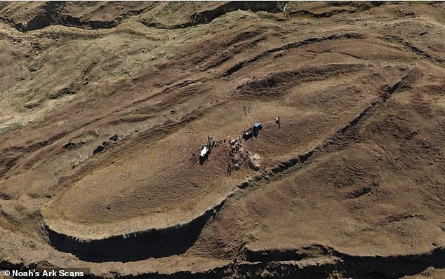
A private research group announced on Wednesday that new radar scans of the Durupınar Formation in Turkey’s Ağrı Province show a large man-made structure underground. Noah’s Ark Scans released a preliminary report claiming the 515-foot boat-shaped mound contains a “man-made object” with corridors, chambers and hallways, not solid natural rock. The findings have not been peer reviewed, and geologists have long described the site as a natural formation.
What the Radar Showed

The scans were run by Dr Khosrow Bakhtar, an engineer who spent decades building detection systems for US defense agencies, including the Air Force, Navy and NORAD. He used a system he invented, called BakhtarRadar, which was originally built to find buried tunnels and hidden structures. The team wanted to know whether the mound was solid natural rock or a built structure with rooms inside.
According to the report, the images showed repeating lines and angles, open passageways, corridors, chambers and hallway-like spaces running the length of the mound. Bakhtar said the images do not look like ordinary rock, mudflow or a solid natural hill in Turkey.
In a statement to the Daily Mail, Bakhtar said the radar is designed to screen out ordinary features such as rock and to pick up buried structures, open spaces and man-made materials. The complex patterns still appeared strongly, so the team concluded the object is not a natural geological formation.

“Natural ground does not organize itself into corridors, chambers and hallways,” Bakhtar said. “The system was built to separate buried structure from host geology, tunnels, voids, worked materials, discontinuities. That is what it is seeing here. A solid geological mass would not have returned this signature.”
He was careful about what the scans can and cannot say. “Whatever the object is beneath the surface is extraordinary,” he said. “In forty years of this work, I have never seen anything like it. It could be a ship. It could be a spaceship. What I can say from the radar is that it is organized, it is structural, and a solid geological mass would not have returned such a strong signature.”
Bakhtar did not say the structure is Noah’s Ark. He said it is organized and structural, and he left the question of what it is open.
Core Drilling Is Underway

Physical sampling began in late September 2026 under a Turkish university-led field program. The first holes hit a very hard layer about 12 to 15 feet down inside the formation. Those samples are being sent to outside labs for testing.
The team told the Daily Mail earlier that core drilling also found a layer rich in organic material. Researchers are testing it to see whether it contains decayed wood.
The full radar scan is expected to be finished by November 2026. More lab results will follow later.
The Next Test Is Animal DNA
The group ties the site to the Book of Genesis, where the flood story says a catastrophic flood destroyed life on earth. Some biblical chronologies place that flood more than 4,300 years ago. In Genesis 6:19-20, God tells Noah to bring male and female pairs of each kind of animal onto the ark so they could survive.
Noah’s Ark Scans says the next major step is testing for animal DNA inside the structure. The group is in talks with scientists who specialize in recovering and reconstructing ancient and extinct animal DNA from deteriorating material. That includes old bones, teeth and other remains buried for thousands of years.
Andrew Jones, vice president of the Noah’s Ark Research Project and founder of Noah’s Ark Scans, made the announcement on Wednesday. “We now know we are looking at a massive, 515-foot, boat-shaped man-made structure with organized patterns and corridors in the Mountains of Ararat, where Genesis places the Ark,” he said.
Jones also said what the group still has to prove. “The challenge is how we prove this is the vessel that preserved living creation through a catastrophic flood,” he said. “That proof will not come from another scan. It will come from identifying and confirming ancient animal DNA inside the voids Dr Bakhtar mapped inside the structure.”
That statement sets the standard the team has chosen for itself. By Jones’s own account, radar images alone will not settle the question.
A Site With a Long Dispute
A Turkish Army captain named İlhan Durupınar spotted the formation in an aerial photo in October 1959, during a NATO mapping mission, and the site later took his name. A group that surveyed it in September 1960 spent two days digging and dynamiting inside the boat-shaped formation and found only soil and rocks. WikipediaWikipedia
Geologists assert that the formation is entirely natural, though they have nominated it as geological heritage. The new claims challenge that view, but they rest on the group’s interpretation of data from its own radar system. No independent scientists have reviewed the report yet. wikipedia
Several results could change that. Lab tests on the hard layer and the organic layer could show whether the material is wood or rock. A finished radar scan would give the team a full map to compare against the preliminary images. Animal DNA, if any is found, would be the strongest evidence the group has named so far. Outside review of any of these results would decide whether the claim holds up.
What Happens Next
Noah’s Ark Scans says the radar shows a built structure with corridors and chambers inside a 515-foot mound in eastern Turkey. Dr Bakhtar says the signal is too organized for solid rock. Jones says proof that this is the ark has to come from DNA.
Until then, the open items are concrete. Lab results on the drilled samples are pending, the full radar scan is due in November 2026, and the DNA discussions have not produced a test. Each of those steps will show whether the preliminary report holds up.