
The United Nations General Assembly has voted to abandon the centuries-old Mercator map in favor of a projection that shows Africa’s true size, following a resolution that split the assembly largely along the same lines as recent votes on colonial history.
The “Correct the Map” resolution passed with 164 votes in favor. The United States cast the only vote against it. Six countries abstained. Togo sponsored the measure with backing from African Union member states, and it drew support from major Western powers including France and the United Kingdom.
The vote carries no binding force. It will, however, push institutions worldwide to reconsider which map they display and teach from.
Why the Old Map Distorts Africa
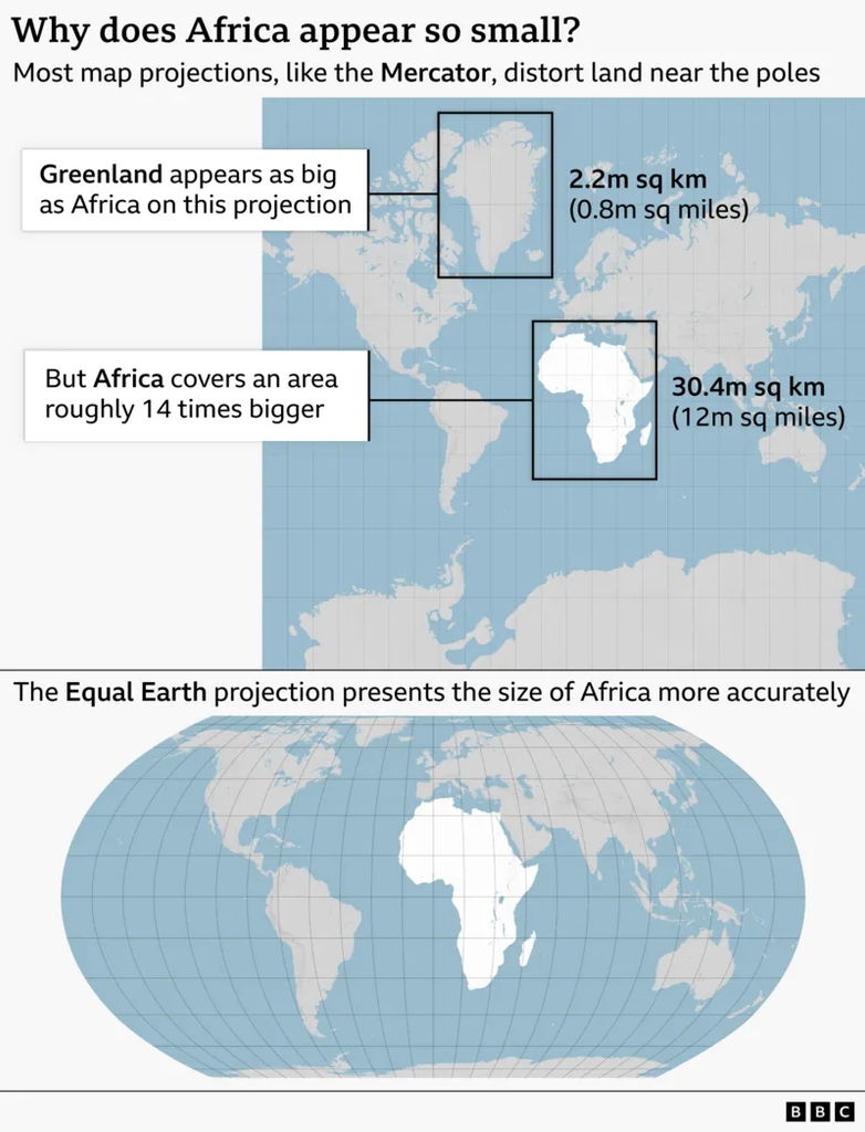
The Mercator map has served as the default world map since Gerardus Mercator, a Flemish cartographer, drew it in 1569 to help European sailors navigate the globe. On that map, Africa appears roughly the same size as Greenland. In reality, Africa is about 14 times larger.
The distortion is not intentional bias built into the design. It is a mathematical consequence of projecting a round surface onto a flat sheet. Every world map involves trade-offs, and Mercator’s version compensates for the Earth’s curvature by inflating landmasses near the poles while shrinking those near the equator.
Critics argue that this visual shrinkage has real consequences. Countries near the equator, many of them in Africa, end up looking smaller and less significant than they are, a distortion that can shape how their development needs and global standing get perceived.
A Newer Map Takes Its Place
In 2018, a group of cartographers built an alternative called the Equal Earth projection, designed specifically to preserve accurate land area across the globe. African Union member states adopted the Equal Earth map in February, stating it “more accurately represents the sizes of all continents, particularly Africa.”
The online campaign group #CorrectTheMap has used a striking comparison to make the case for the change: Africa’s actual landmass could contain the United States, China, India, Japan, Mexico, and much of Europe combined, with room left over.
Diplomatic Push Behind the Resolution
Togolese Foreign Minister Robert Dussey led the diplomatic effort ahead of Friday’s vote. He told Reuters that a fair world begins with a fair map. In an earlier UN briefing, he argued that maps are never neutral, saying they shape how people understand the place of nations and continents in the world.
French Foreign Minister Jean-Noël Barrot backed the resolution and announced that his ministry would stop using the Mercator map altogether. He acknowledged that changing a map does not change the underlying world, but said correcting a distorted representation is itself an act of truth.
US Pushes Back
The American delegation rejected the resolution outright. Yaryna Ferencevych, a US representative at the UN, said the measure trivialized the assembly’s core mission. She argued that the body should be addressing international peace and prosperity rather than debating a 16th-century map projection and its connection to reparations and what she called “cognitive justice.”
This is not the first time the US has broken from the majority on a symbolic UN measure tied to historical grievance. In March, the US also objected when the assembly adopted a resolution declaring the transatlantic slave trade the gravest crime against humanity.
What Changes Now
Because the resolution is non-binding, no country is required to switch maps. But the vote gives institutions, ministries, and schools a clear signal from the world body, and France has already committed to dropping Mercator in official use. Whether other nations follow will likely shape how quickly the Equal Earth projection replaces the 456-year-old standard in classrooms, atlases, and government offices worldwide.